
|
Satellite "Kanopus-V"
(Under construction)
Content
Satellite "Canopus-V" was named after star Canopus and project "Vulcano". But in technical documentation with SSTL there was name "Kanopus-V". And now I don't know right name - "Kanopus-V" or "Canopus-V".
Table 1.
Main characteristics of satellite "Kanopus-V" [1]
| Параметр | Значение |
| Weight, kg | 261 |
| Camera weight, kg | до 200 |
| Power supply, W | 350 |
| Reaction mass | 7 years |
| Memory on board | 27 Gb |
| Band width, Mb/s | 2X122,8, Х band |
| Orbit height, km | 510 - 540 |
| Inclination (ССО) | 97.4° |
| Life time, years | 5-7 |
| Orientation | 3- axes |
| Orientation accuracy | 5 arc min. |
| Stabilisation accuracy | 0,001 degrees/s. |
| Command line | |
| Band | S |
| Speed in channel «Earth-Board» | 9,6 kbit/s |
| Speed in channel «Board-Earth» | 64 kbit/s |
| Transmitter power | 250 mW |
| Power supply | |
| Solar panels | GАs |
| Accumulator | Li-Ion |
| Engine | |
| Engine type | СПД |
| Fuel | xenon |
| Engine temperature | 500°С |
| Reaction mass | 11 – 35 kg |
| dV | 32,2 – 100 m/s |
| Ground samole distance: | |
| panchromatic | 2,1 m |
| multispectral | 10,5 m |
| Span width from height 510 km in nadir | > 20,0 km |
| Swath from height 510 km roll angle ±40° | 1020 km |
| Revisit time in nadir on equator | 5 days (16?) |
| Shooting time | < 700 s |
| Productivity | > 2 mln sq km/day |
Table 2.
Satellite "Kanopus-V" cameras
Характеристики |
Panchromatic shooting system (PSS) |
Multispectral shooting system (MSS) |
GSD |
2.1 m |
10.5 m |
Spectral band (level 0,5) |
0,52 - 0,85 mkm |
0,54 – 0,6; 0,63 – 0,69; 0,69 - 0,72; 0,75 - 0,86 |
Span width |
23.5 km |
20.2 km |
Focal length |
1797,5 mm. |
359,5 mm |
Эффективное относительное отверстие |
1:10,3 |
1:5,6 |
Светопропускание |
0,7 |
0,6 – 0,8 |
|
45,3 km |
195 km |
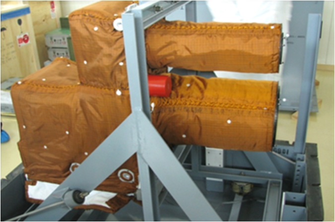
fig. 1. Cameras block (big tube- PSS sensor).
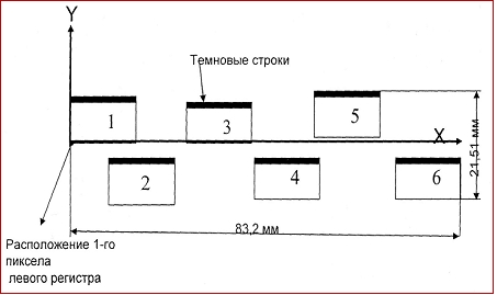
fig. 2 PSS sensor micromatrix position
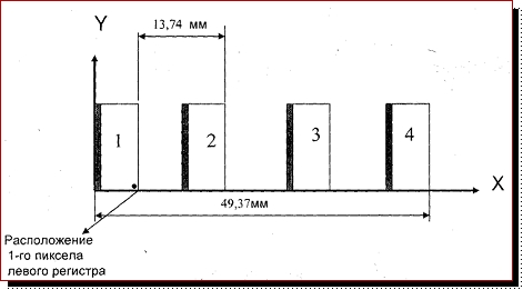
fig. 3 MSS sensor micromatrix position
Test area Pyatigorsk, Russia
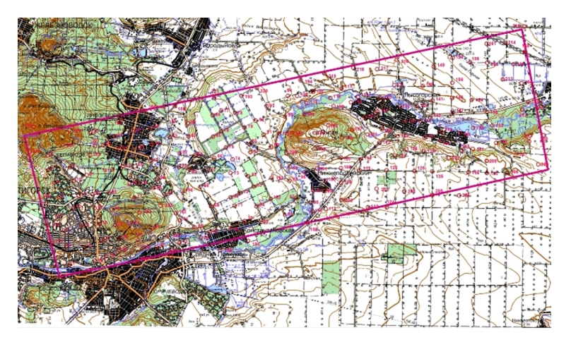
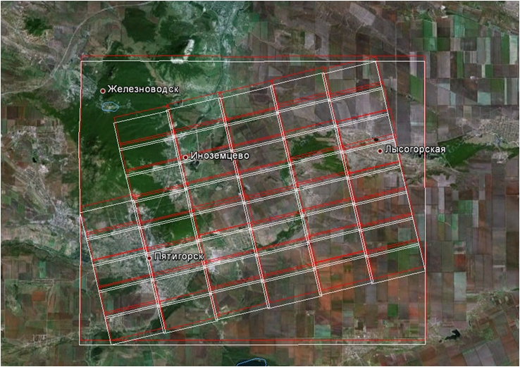
Рис. 4 Pyatigorsk PSS microframes coverage after processing in "GeoKA" software (primary shift is about 500m, resulting error less, than 10m)
Programs for processing microframes of satellite "Canopus-V"
Processing of satellite "Canopus-V" microframes in standart software, such as ERDAS Imgine, ENVI you need to have files with RPC-coefficients. Ther are such data in imagery metadata, but format is unknown for standart software. For creation of this data was developed Meta2Poly utility. It create RPC-files and creates footprints for visualization in GoogleEarth (kml).
You may download it here.
Utility is freeware, it works for 15 days, then you need to register it, FREE OF CHARGE!. Send me Machine ID and I send you registration during 3 days on your e-mail.
Test sample from NTSOMZ site (satellite operator)
Only 78 PSS microframes evaluated for Beijing track. No synthesized images or multispectral image were evaluated. Evaluation was done for images with minimal processing to evaluate georeferencing accuracy from navigational data (without control points). Microframes coverage is shown on figure 5.
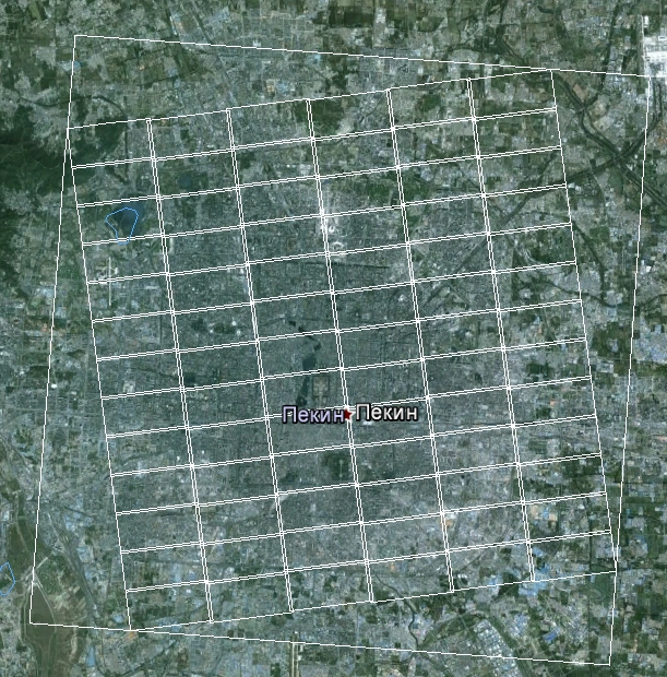
Fig. 5. Beijing - PSS microframes coverage
Test track from NTSOMZ site was shooted 1/11/2012 - not very fresh, but it was done after end of flight tests. We thought that accuracy will be better than was declared on State comission (see table 3).
Таблица 3.
Georeferencing accuracy from navigation data, declared on Stata comission 30.oct.2012
Track |
Shooting date |
Level 2 |
Level 3 |
RMS, m |
RMS, m |
||
KV1_01104_01098_02_3NP2_01 |
02.10.12 |
73.37 |
28.20 |
KV1_01105_01103_01_3NP2_08 |
02.10.12 |
109.84 |
30.66 |
KV1_01126_01123_01_3NP2_08 |
04.10.12 |
19.90 |
14.89 |
KV1_01126_01125_01_3NP2_08 |
04.10.12 |
166.74 |
20.53 |
KV1_01126_01126_01_3NP2_08 |
04.10.12 |
49.83 |
49.06 |
Now (04.feb.2013) accuracy evaluation is done only for 2 microframes. Georeference data taken from metadata - navigation data. Evaluation showed that accuracy is worth than declared. Results are shown in table 4.
Table 4.
PSS Microframes georeference accuracy evaluation
| Microframes | shift dx | shift dy | points | RMS |
| KV1_01553_01549_01_419.tif | 204.23 | 75.33 | 8 | 13.0 |
| KV1_01553_01549_01_421.tif | 245.16 | 93.11 | 8 | 19.3 |
Literature
1. Gorbunov А.В., Slobodskoy I.N. Космический комплекс оперативного мониторинга техногенных и природных чрезвычайных ситуаций «Kanopus-V» Geomatica, 2010.
THE COPYRIGHT of THIS DOCUMENT IS THE PROPERTY OF Victor Nekrasov.
All rights reserved. No part of this documentation may be reproduced by any means в any material form
(including photocopying or storing it в any electronic form) without the consent of the Copyright Owner or under the terms of a licence and/or
confidentiality agreement issued by the Copyright Owner, Victor Nekrasov. Applications for the
copyright owners permission to reproduce any part of this documentation should be addressed to, Victor Nekrasov, vinek@list.ru
© 1998-2023 Victor Nekrasov